
Geologic Hazards
A geologic hazard is a geologic condition that exists that has the potential to cause a threat to life and/or property. These geologic conditions become hazards when humans get in their way. A few examples include landslides, earthquakes, coastal hazards, and sinkholes. In order for citizens and government officials to make informed land-use decisions, it is imperative that the geologic experts at the North Carolina Geological Survey (NCGS) provide information on these hazards. NCGS identifies where significant geologic conditions exist and provides this information to government and emergency response officials. The hazard information is critical for the creation of responsive plans in the event that the geologic conditions become geologic hazards.
Landslides
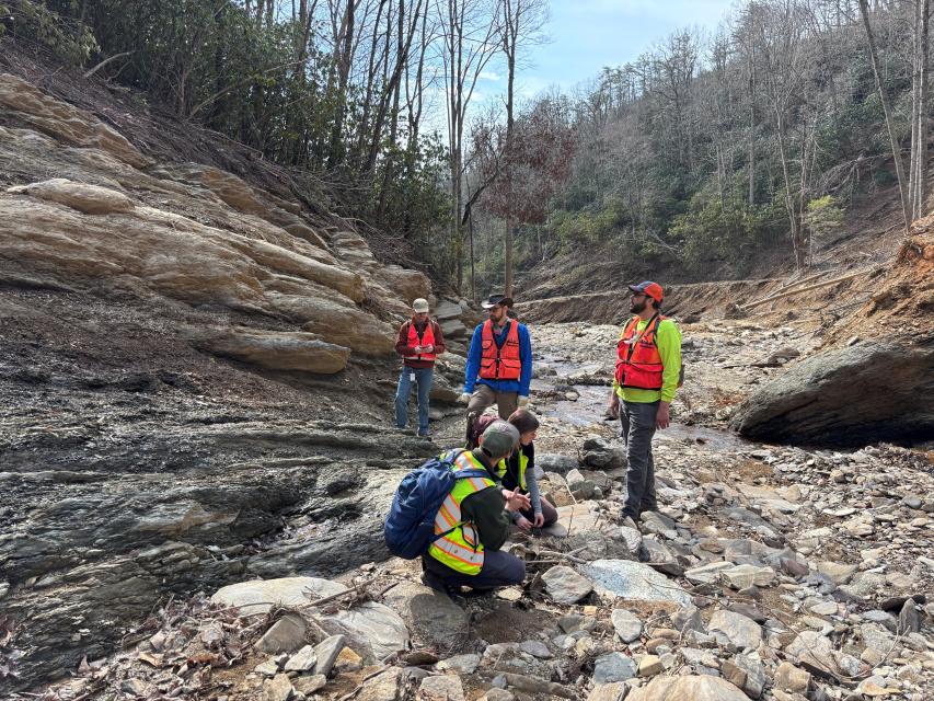
The NCGS landslides hazards program comprises the bulk of the workload for the Geologic Hazards and Engineering Team. The Team partners with UNC-Asheville's National Environmental Modeling and Analysis Center (NEMAC) to support data delivery and visualization of accurate, useful, and current landslide hazards through a variety of web products, with the goal of making it easier for various audiences to access, interact with, and understand landslide hazard data.
Resources - Landslide Website and Mapping Tool
Landslides in Western North Carolina
The North Carolina Geological Survey has launched a new landslide website and GIS-based mapping tool to better inform communities about landslide hazards. NCGS, within the Division of Energy, Mineral, and Land Resources, worked with the National Environmental Modeling & Analysis Center at University of North Carolina Asheville on the project. This interactive website allows users to explore current and historical information about landslides in North Carolina. Users can access resources to help them plan for and build resilience to landslide hazards.
Resources - Landslide Data Viewer
Western North Carolina Landslide Data Viewer
Additionally, the NCGS has launched the Landslide Hazards in Western North Carolina Data viewer that will simplify the process for audiences to access, interact with and understand landslide hazard data. The NCGS landslide team surveys and documents landslide locations and impact areas using a Geographical Information System (GIS) that combines satellite and aerial imagery, unmanned aerial vehicles, and field work to produce the Data Viewer. The Viewer includes a current inventory of landslide points (where landslides started), landslide outlines (the approximate extent of individual slope movements), and landslide deposits (the extent of significant volumes of earth, debris and rock fragments that have accumulated due to past debris flows and debris slides, rock falls and rockslides), mapped and published by NCGS.
Landslide Resources - Who should use them?
Both the publicly-available website and data viewer are designed for use by community planners, emergency management personnel, design consultants, educators, real estate professionals, and affected citizens. The NCGS currently published landslide inventory contains information on more than 4,500 landslides. Data is available for download and is updated as landslides occur in North Carolina.
General Landslide Information
Landslides are most common in the mountain region of North Carolina because of steep slopes. The Piedmont and Coastal Plain regions also have landslides that are commonly related to human activity such as making a road cut too steep. Large rainstorms, hurricanes, freeze-thaw processes, and human activities can also trigger landslides.
Landslides can be very small, like those on the side of a ditch, or they can be as large as mountainsides. In addition to the triggers listed above, landslides can be caused, in part, by the nature of the underlying rock. Most rock formations have layers like a stack of books. If you tip the stack of books, they slide off of each other, just like tilted layers of rocks can slide off a mountainside. The layers of rocks are planes of weakness where the landslide separates from the side of the mountain. Geologic maps like the ones produced by the NC Geological Survey show how these planes are oriented.
There are many types of landslides that are made of different materials that travel at different speeds. The specific behavior of individual landslides is most often unpredictable, even when studied in detail. When they move, and by how much, is often speculative. Cycles of wet weather and above average rainfall, particularly when followed by large storms, can trigger landslides.
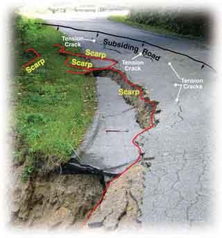
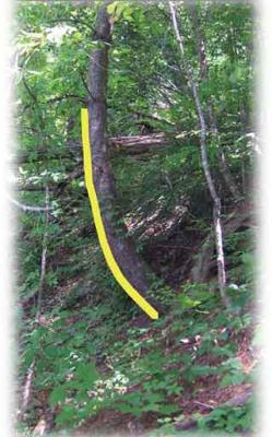
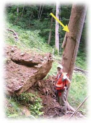
Geologists look for signs of land movement such as tension cracks, which form when the ground pulls apart and may lead to a downhill slide creating a scarp and eventually a lighter, vegetation-free scar. Another indicator is trees with bent trunks; as land slowly shifts downslope, trees can lean but grow upward towards sunlight, resulting in curved growth patterns. These clues warm that significant movement could occur during heavy rainfall.
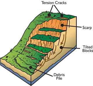
Debris (soil-rock mixture) or earth (clay-silt soil) slides usually move at a slower rate than debris flows because the water content is too low for the mass to liquefy. The can be due to the higher clay content of the soil that requires more moisture to liquefy. Movement rates are typically on the order of inches per day to feet per day, particularly during wet periods. During wet weather cycles, slides can be self-perpetuating. Initial movement opens tension cracks and scarps providing pathways for water to infiltrate deeper into the slide mass, thereby further decreasing the stability of the slope. Further movement widens existing tension cracks and scarps, allowing more infiltration pathways, and so on. Shearing along the side planes usually decreases the soil strength, a further destabilizing factor.
Movement Indicators
Ground Slopes:
- Enlarging tension cracks and scarps, especially those forming upslope of the main scarp
- Leaning, tilting, or dying trees
- Tree roots stretched across tension cracks
- Bulging or hummocky ground surface
- Changes in normal drainage patterns
- Surface water entering the slide mass
- Culverts or other road draining patterns directing runoff towards the unstable area
Structures:
- Cracked masonry or pavement
- Walls, posts, rooflines not plumb or level, or buckling
- Tilted or cracked chimneys
- Windows and doors sticking, broken glass
- Plumbing or gas line leaks
- Leaning utility poles, street signs
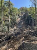
The image below shows an apartment complex in Maggie Valley, NC that is built on an old landslide and stream deposits at the base of a mountain. The landslide deposits have accumulated because of recurring landslides and where they have happened in the past, they can happen in the future. The inset image on the rifht shows general elements of a debris flow.
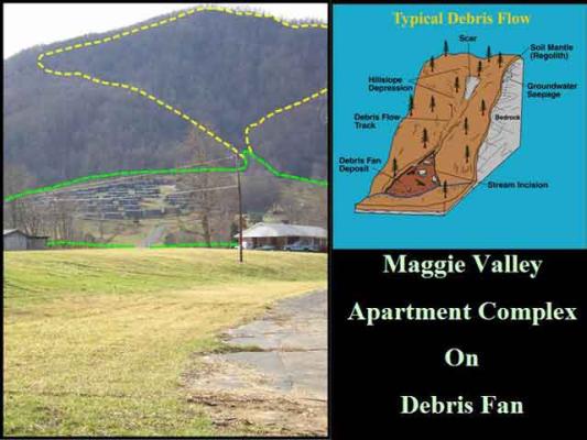
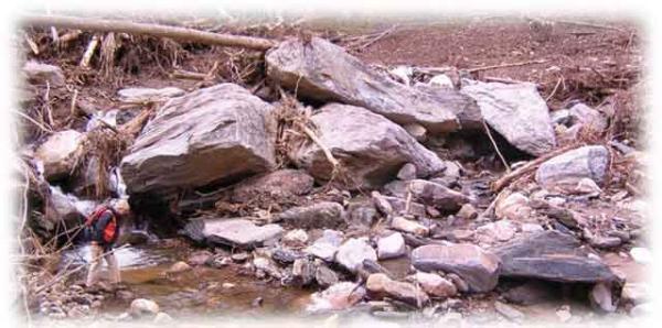
Debris flows are rapidly flowing mixtures of soil, rock particles, and water. The media, when referring to debris flows, often use the term "mudslide". The soil mass that initially moves is usually a rocky, silt-sand mixture that is not highly plastic or cohesive (i.e. one that contains a lot of clay). The lower cohesion allows the soil to "liquefy" during heavy rains and to move rapidly, up to 30+ miles per hour (mph) down slope. Once movement begins, there is often insufficient time to move to safety. Debris flows often originate in hollows on steep mountain slopes where thin (less than 6 feet) soil overlies hard bedrock. The failed soil mass usually (though not always) travels down an existing drainage and accumulates into a lobe-shaped mass near the toe of the slope. Steeper slopes (greater than 25-30 degrees) combined with a long run-out distance between the point of origin and the flatter toe-slopes create the potential for fast movement.
Debris flows often originate in hillslope depressions, or hollows, near the headwaters of mountain streams. Often triggered by intense rainfall, debris flows typically follow mountain stream channels. Building homes or other structures at the base of steep slopes (greater than 30 degrees), especially near stream channels, increases their vulnerability to damaging debris flows. Land-disturbing activity on steep slopes can also increase the likelihood of debris flows.
Indicators That Further Movement is Likely in the Upslope Area
- Unstable (loose, wet soil) material remaining in the scar area - exposed bedrock in the scar and along the track indicates the bulk of the material may have already been taken downslope and the situation is relatively more stable
- Tension cracks, scarps, or leaning trees above the scar area
- Seepage or flowing water exiting the slope within or above a mass of soil remaining on the slope
- Water exiting the slope at the soil-rock contact
- Culverts or other road drainage patterns directing runoff toward the unstable area
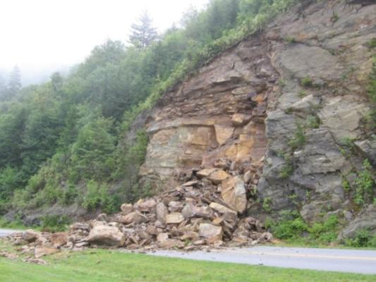
Rock slides and rock falls usually occur along roadways but can occur on any modified or natural rock slope. They can occur in conjunction with heavy rainfall, but often occur at other times usually without notice. Freeze-thaw cycles and wedging by tree roots can loosen blocks of rock from a slope. Rock can easily weigh 165 pounds per cubic foot so there is not much rock needed to cause property damage or injury. A rolling and bounding basketball-sized rock can easily go through a roof. Rocks slide or fall because of pre-existing planes of weakness within the rock mass. Where these planes of weakness are inclined toward, or intersect, an excavated slope, the odds of a rock slide increase.
Indicators of Movement
- Apertures (openings) between blocks of rocks
- Surfaces of the planes of weakness are degraded or weathered, particularly with red-brown to yellow-brown staining
- The location has a past history of rock slides
- Visible, flowing water along planes of weakness
Stabilizing Rock Slopes
- Stabilizing a rock slope can be very expensive and requires specialized equipment along with engineering experience and expertise
- Engineered drilled-in rock bolts
- Engineered wire mesh blankets, usually only effective for containing small blocks of rock on a slope
Each case is unique and involves evaluating a number of alternatives. Stabilizing a slope can easily exceed the monetary value of a house. Covering a slope with plastic or placing rock on the slope is a short-term fix, at best. It is very easy to waste money on attempts to stabilize a moving slope.
We offer the following list of alternatives:
- Can the structure, such as a mobile home, be moved to a nearby stable or safe location?
- In most cases, the successful long-term stabilization of a slope above or below a home requires the services of a geotechnical engineer experienced in the soil and rock types in the affected area.
- Knowledge of the extent, geometry, and properties of the unstable material relative to the structure must be known, or conservatively assumed, to help ensure successful and cost effective stabilization. For examples, if a home is built on an embankment, what is the extent of the embankment and where is the pre-existing natural ground surface?
- Are the unstable slopes above or below the structure, or both?
- Can the unstable material be removed or regraded to leave a slope stable?
- If the unstable slope cannot be removed to preserve the structure, can the slide mass be stabilized in place?
- Does the design life of the stabilization equal or exceed that of the structure to be saved?
- What is the allowable differential settlement of the structure to be versus the degree of settlement allowed by the stabilization effort?
- Walls over 4-6 feet high should be designed by an experienced geotechnical or structural engineer familiar with the materials used in the wall and the material being supported by the wall. Common types of successful engineered retaining walls used to stabilize slopes above and below a structure:
- Gravity walls - usually made of rock, concrete, or concrete block
- Driven H-piles with treated timber lagging (with or without tie backs)
- Reinforced earth walls - geotextile layers within a compacted earth fill
- Wire rock baskets (e.g. gabions)
- Other stabilization methods:
- Pressure grouting
- Soil nailing
- Drainage (e.g. horizontal drains)
- Walls typically used for landscaping (e.g. railroad ties or stacked, treated lumber) have sever limitations when used to stabilize a slope to protect a home. Timber walls typically have a design life of less than 15 years.
- Proper surface and subsurface drainage is a key component of successful slope stabilization. Gutters and septic systems can add unwanted water to stable areas.
Landslides from Tropical Storm Cindy (July 2005) — The remnants of Tropical Storm Cindy tracked across western North Carolina on July 6-7, 2005. A four-year-old volunteer fire department building was damaged making it unsafe to occupy.
Landslides from Hurricane Frances(September 2004) — The remnants of Hurricane Frances tracked across western North Carolina on September 8, 2004. In addition to flooding, property damage and interruption of transportation corridors occurred owing to landslides and downslope movement of earth and rock triggered by very heavy and intense rainfall.
Landslides from Hurricane Ivan(September 2004) — The remnants of Hurricane Ivan tracked across western North Carolina on September 16-17, 2004. In addition to flooding, property damage and interruption of transportation corridors occurred owing to landslides and downslope movement of earth and rock triggered by very heavy and intense rainfall.
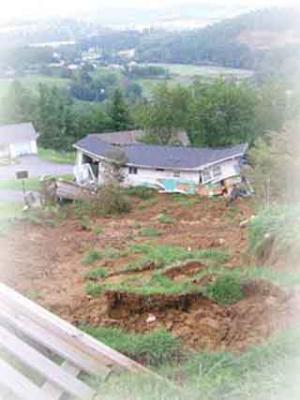
Peeks Creek Community, Macon County — (September 2004) about $1.3 million in property damage occurred during this event related to Hurricane Ivan. Tons of water, mud, rocks, trees, and other debris traveled for more than two miles at speeds of up to 33 miles per hour. The debris flow was 30 feet deep and 250 feet wide at some points as it traveled downhill.
Interstate I-540, Wake County(summer 2000) — While landslides are more frequent in the mountainous part of North Carolina, landslides also occur in other parts of the state. One landslide example occurred in the summer of 2000 along Interstate I-540 in Raleigh in Wake County.
Holly Springs, Wake County (summer 2003) — Piedmont earth movements have affected homes as well. In May 2003 a soil embankment failure in Holly Springs, Wake County, North Carolina, affected a number of homes.
Blue Ridge Parkway (April 24, 2003) — A landslide closed the Blue Ridge Parkway in April 2003 following heavy rains.
2024 Hurricane Helene
On Friday September 27, 2024, Hurricane Helene's wind and rain reached an already-saturated western North Carolina. Three day rainfall totals exceeded eight inches in the mountain region, with 12+ inches recorded in many areas. According to the NC Office of State Budge and Management's Hurricane Helene Recovery Assessment, the highest local rainfall maximums across the state exceeded 30 inches for only the second time in recorded state history. Many rivers and streams that were already at flood stage because of earlier precipitation events swelled to record highs, producing 1,000-year flood events in several North Carolina counties. Helene's impacts, particularly flooding and landslides, made it one of the deadliest storms in the U.S. in the 21st century. There were more than 100 human fatalities in North Carolina.
The NC Geological Survey, in a multi-state cooperation with federal officials, has a dashboard to view Hurricane Helene landslide observations. As of November 2025, the Landslide Hazards Program Team responded to over 400 landslides reported by NC Emergency Managers and the citizens of western North Carolina.
Earthquakes in the Southeast U.S.
Earthquakes occur far more frequently in the western U.S. than in the east. The East Coast lies on a passive continental margin, positioned near the center of a tectonic plate rather than along an active boundary. Earthquakes in the southeastern U.S., including North Carolina, are classified as intraplate seismic events. These originate from ancient, buried geological structures such as faults rather than current plate activity. In contrast, the West Coast is seismically active, with numerous faults that produce frequent and damaging earthquakes.
For additional details on earthquake causes, locations, and measurement methods (e.g., Modified Mercalli Scale, Magnitude Scale), refer to the NCGS Earthquakes Factsheet and the IRIS Factsheet entitled "How Often Do Earthquakes Occur?".
IRIS - How Often Do Earthquakes Occur?
Earthquake data prior to 1886 are limited, as seismic instruments were not installed in the region until the late 1920s. Before this time, earthquake records relied on historical accounts. The distribution of seismograph stations didn't allow for accurate detections of earthquakes with magnitudes below 4 until 1962-1963. Micro-earthquake monitoring networks began operating in the mid-1970s.
The NCGS Geologic Hazards Map Series 2, which includes earthquake epicenters in North Carolina and adjacent states, is available for download on the NCGS website.
Highlighted below are notable earthquakes that have originated in North Carolina. Information for events from 1861-1981 is from the United States Geological Survey Professional Paper 1527.
Notable NC Earthquakes
August 31, 1861. 10:22 am.
'Bricks were shaken from chimneys, doors were jarred open, and clocks stopped running at Wilkesboro, about 85 km west of Winston-Salem. Felt along the Atlantic Coast from Washington, D.C., southward to Charleston, S.C., and Columbus, Ga., and westward to Cincinnati, Ohio, Louisville, Ky., and Gallatin, Tenn. Magnitude 5.1 Mfa'
February 21, 1916, 6:39pm
Magnitude 5.2 Mfa, Modified Mercalli Intensity VII
'Tops of chimneys were thrown to the ground; windowpanes were broken in many houses; and people rushed into the streets at Waynesville. At Sevierville, Tenn., about 70 km northwest of Waynesville, bricks were shaken from chimneys. In Wear's Cove, about 16 km southwest of Sevierville, the flow of water in springs increased and in places water became muddy. Minor damage was reported in western Tennessee at Athens, Knoxville, Maryville, Morristown, and Newport, Tenn.; at Tryon, N.C.; and at Bristol, Va. Also reported felt in Alabama, Georgia, Kentucky, South Carolina, and West Virginia.'
The following are excepts from a post by former NC State Geologist, Dr. Kenneth B. Taylor, P.G., written to commemorate the 100th anniversary of this earthquake:
- ..."the Skyland earthquake which strongly shook western North Carolina and was felt in South Carolina, Tennessee, Georgia, Virginia, Alabama, Kentucky, and West Virginia, an area exceeding 200,000 square miles. The farthest location to report feeling the quake was Norfolk, Virginia, 365 miles away."
- "The Skyland, N.C. earthquake was instrumentally recorded at Harvard University (Cambridge, Massachusetts) 1,250 miles away; Canisius College (Buffalo, New York); University of Kansas (Lawrence, Kansas); Saint Louis University (St. Louis, Missouri); Georgetown University (Georgetown, Maryland), and the Weather Bureau (Washington, District of Columbia."
July 8, 1926, 9:50am
Modified Mercalli Intensity VII
'A sharp local earthquake in Mitchell County caused minor damage - one downed chimney, cracks in chimneys and foundations of houses, broken water pipes and glassware, and shifting of houses on foundations. Ground cracks also were reported. Damage was confined to an area about 1 km long and 275 m wide. Town names were not mentioned in any of the accounts on this event.'
May 13, 1957, 2:24pm
Magnitude 4.1 Mfa, Modified Mercalli Intensity VI.
'A sprinkler pipe was shaken loose at a factory in Woodlawn, and books fell from library shelves. Slight damage to plaster occurred at several town in the area. Old cracks in a wall were enlarged at Busick, near Mt. Mitchell in southern Yancey County. The shock was strong in other town in Burke and McDowell Counties and was reported felt at two towns in South Carolina.'
July 2, 1957, 9:33 am.
Modified Mercalli Intensity VI.
'Minor damage reported in western North Carolina included cracks in walls and plaster at Asheville, cracks in retaining wall at Marshall, damaged chimneys and cracks in plaster at Swannanoa, and cracks in plaster at Weaverville. Also reported felt in Haywood and Madison Counties, N.C., and at Flag Pong, Tenn.'
November 24, 1957, 8:06pm.
Magnitude 4.0 Mfa, Modified Mercalli Intensity VI.
'At Hartford Tenn. (about 70 km southeast of Knoxville), slight damage to buildings included a crack in one wall and a kitchen that was separated from the rest of the house. The earthquake shifted furniture in Jackson County, at Cherokee and Sylva, N.C., about 50 km south of Hartford, Tenn. Also felt in South Carolina.'
May 5, 1981, 9:21pm.
Magnitude 3.3 Md, Modified Mercalli Intensity VI.
'Cracks formed in windows and a concrete patio in Hendersonville, and one sidewalk shifted 5 cm. Cracks also occurred in drywall and a house foundation a few kilometers southeast of Hendersonville, at Zirconia. Water in several wells became muddy in the Dana area. Also felt in South Carolina, Tennessee, and Virginia.'
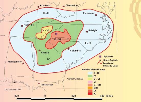
The Mw 5.1 earthquake near Sparta, NC was the largest earthquake in the state in over 100 years and was the second strongest in the eastern U.S. since the Mineral, Virginia earthquake of 2011 (Mw 5.8). The maximum Modified Mercalli Intensity was VI-VII (strong to very strong). The hypocenter was shallow, approximately 2.5 miles (4.7 km) below the surface, according to the USGS. The 5.1 magnitude earthquake caused visible ground rupture due to faulting, which has never been documented in the U.S. east of the New Madrid Seismic Zone. Subsequent research and ground excavation revealed the previously-unmapped Little River Fault which trends west northwest to southeast, parallel to the Little River in some locations. The Little River Fault is an oblique reverse fault, caused by horizontal compressional stress, common in areas of tectonic plate convergence. There were eight foreshocks ranging in magnitude from M1.8-2.6 and approximately 300 aftershocks over the next six months. The largest aftershock had a magnitude of M2.9 but most were less than M1.5.
Approximately $15 million dollars worth of damage occurred as a result of this earthquake, mostly to foundations, chimneys, roads, and utility lines.
The Geological Society of America's GSA Today publication, Volume 32 Issue 3-4 provides a comprehensive account of data from the 2020 earthquake.
Other Geologic Hazards in North Carolina
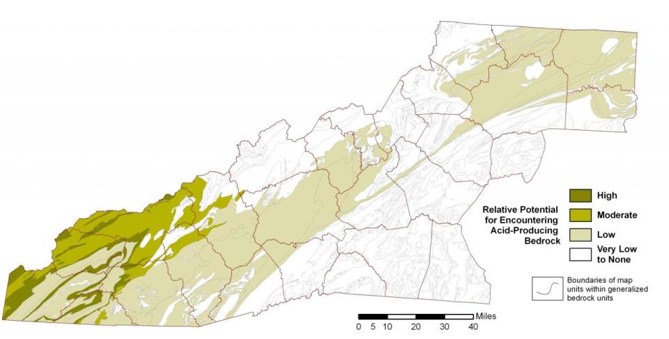
North Carolina has several different types of rock and soil that can produce acid when exposed to air and water. While releases of acid are easily controlled, acidic water can be harmful to plants and animals if left unchecked. Also, these rock types may be more susceptible to landslides. The North Carolina Department of Transportation pays close attention to road construction in areas of acid-producing rock.
Western North Carolina
Areas of bedrock with acid-producing potential are common in the Blue Ridge Mountains of western North Carolina. Much of the rock contains trace amounts of naturally-occurring iron sulfide minerals such as pyrite (fool’s gold) pr pyrrhotite, usually occurring in concentrations below what’s necessary to produce harmful environmental impacts when exposed. Other acid-producing rocks, primarily those among the metamorphosed sedimentary rocks of the western Blue Ridge, can contain sulfide minerals in sufficient concentrations to warrant mitigation measures when encountered during engineering projects.
When exposed, oxidation and hydrolysis of the sulfide minerals can produce damaging sulfuric acid with pHs as low as 2.5 and can weather the surrounding rock at accelerated rates. Excavation into unweathered sulfide-rich rock can increase the potential for acid production, but is typically not a concern unless significant amounts of unweathered rock is exposed. Produced acid can infiltrate rock fissures and slopes, increasing weathering, thus leading to rockslides and surface instabilities.
When acidic runoff enters streams, sudden decreases in pH may occur and can degrade water quality, causing significant mortalities among acid-intolerant aquatic organisms, such as during the 1963 reconstruction of U.S. Highway 441 in the Great Smoky Mountains National Park. Acidic runoff is usually greatest shortly after road construction but can continue at decreased levels years after construction. Mine waste and tailings from some abandoned mines can also produce damaging acid runoff, such as with the Ore Knob Mine in Ashe County.
Similarly, acid-producing rocks can adversely affect the stability of slopes, particularly if untreated material is used in the construction of embankments. Acid-producing rock was a contributing factor in rockslides on the Blue Ridge Parkway (1999, 2006), and slope failures in Swain County (2003) and Haywood County (2006). To avoid similar damage, the presence of significant amounts of acid-producing rock was a consideration in evaluating alternatives for the North Shore Road extension in the Great Smoky Mountains National Park in Swain County. Given these many concerns, well-established, standard engineering practices have been developed to isolate or neutralize acid-producing rock when encountered in construction.
Sinkholes
Sinkholes are depressions or holes in the ground cause by the collapse of surface materials like rock and soil. Geological (naturally-forming) sinkholes happen when water dissolves soluble rock like limestone, dolostone, salt, or gypsum, creating voids or cavities that fail to support surface materials.
Geological sinkholes can form gradually but can also suddenly collapse due to heavy rain or intense drought. They form primarily in karst terrain and are most common in Florida, Texas, Alabama, and other regions with soluble rock.
Sinkholes in North Carolina
Natural, geological sinkholes are uncommon in North Carolina due to the lack of large areas of karst terrain and soluble rocks. However, there have been instances of natural sinkholes forming in the southeastern Coastal Plain counties of Brunswick, New Hanover, Pender, Onslow, Jones, Lenoir, Craven, and Beaufort due to the limestone that underlies much of the southeastern Coastal Plain.
The coastal population is growing as is the region's need for clean water. As more water is pumped out of the ground for public and private use, the water levels in the limestone cavities will drop. When the water is no longer in the cavity to help support the ceiling, the cavity will be more likely to collapse, forming a sinkhole.
Sinkholes Caused by Human Activity
Sinkholes caused by human activity are referred to as anthropogenic or induced sinkholes. They are often the result of altering water flow, modifying the land, or mining. Induced sinkhole causes include:
- Leaking utility lines: broken water lines, sewer pipes, and/or stormwater drains can erode underlying soil and rock which can lead to ground collapse
- Altered drainage: development and construction can change drainage patterns and create concentrated water flows which in turn can increase erosion
- Groundwater extraction: pumping excessive water from the water table can lower the water table, thereby removing the fluid pressure that supports the overlying rock and soil
- Mining and drilling: underground mining and/or water removal for underground mining can remove support for overlying rock and sediment, thereby leading to ground collapse
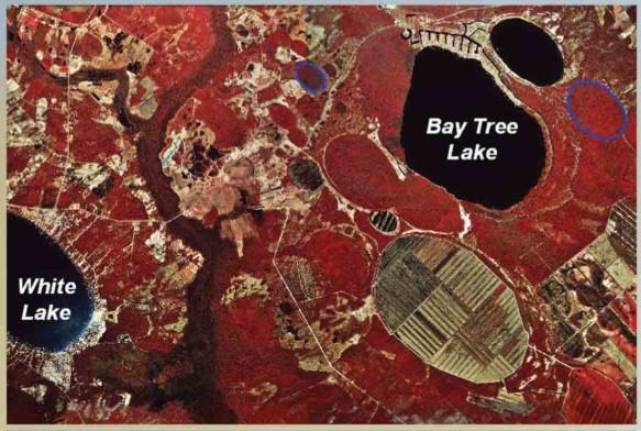
Carolina Bays
Carolina Bays are pond or lake-type features in the southeastern Coastal Plain of North Carolina. They are not sinkholes. They are generally larger than sinkholes, shallower than sinkholes, and do not overlie underground cavities. Most have an oval shape, oriented in a northwest to southeast direction. Not all Carolina Bays for lakes - some have been drained for agricultural use and some are swamps.
Land Subsidence
Land subsidence, up to 0.25 inches/year, has been documented in the North Carolina Coastal Plain and is interpreted to be the result of groundwater withdrawal. You can get more information on land subsidence through the USGS Land Subsidence webpage.
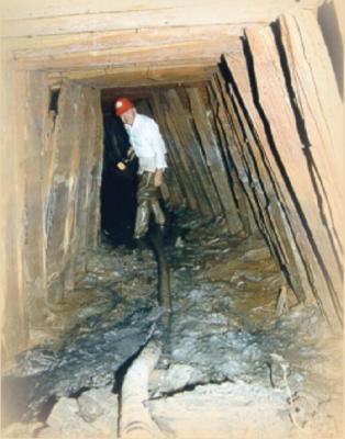
Old Underground Mine Collapse
Most underground mining in North Carolina ended more than 100 years ago but there are still hundreds of abandoned, historic mines in our state. Encountering historic mine workings during construction can have serious effects on a project. Geologic maps and the assistance of a geologist can provide information on past land use in historic mining areas of North Carolina. Abandoned mine collapse in North Carolina is rare but with urban development spreading quickly, it is important to know the locations of old mines.
You can use NCGS Bulletin 84 (Metallic mineral deposits of the Carolina Slate belt) to help you identify metal mines of the Carolina terrane in the Piedmont region.
In 1991, construction activities opened the entrance to a graphite mine on private property in Raleigh. The owner of the property pumped out groundwater from a portion of the mine. The structural timber in the mine were dated to the late 1800s, indicating when the adit (the horizontal opening) was built. The property owner was not aware of any underground mine workings on his property.
Shrink-swell clays, or expansive soils, are clay-rich soils that drastically change volume bases on moisture content. Their mineral structure creates a sponge-like behavior, where the soil can expand and become soft/sticky when wet and contract and harden when dry.
Characteristics
Shrink-swell clays contain clay minerals such as smectite, bentonite, and montmorillonite. These clay minerals have a lattice-type structure that allows water absorption between the layers. A rainy season can cause these soil to retain moisture and well and a dry season can cause the soil to shrink, or decrease in volume.
Hazards and Impacts
- Volume changes (swelling) can lead to heaving upward of the soil to cause building foundations to lift
- Volume changes (shrinking) can lead to soil pulling away from foundations, leading to uneven settlement
Both of these impacts can lead to cracked walls, foundation cracks, uneven floors, and broken utility pipes and lines.
If you think your property may be underlain by clay soil soil that is expansive, contact your insurance company for more information.
Mitigation
A geotechnical engineer can identify expansive soils before construction. Potential mitigation measures, as specified by a geotechnical engineer, can include: moisture barriers, specialized foundation designs, removing or replacing soil, and sometimes chemical stabilization (adding lime to soil).
Where do they occur in North Carolina?
Expansive soils can occur in almost any location in the Mountain, Piedmont, or Coastal Plain of North Carolina. The greatest potential is in the Carolina terrane and the Triassic Basins.
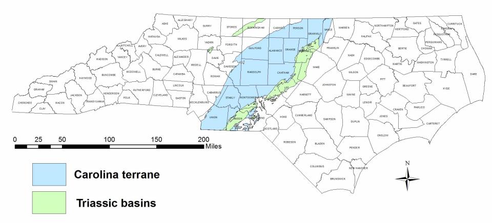
The rocks of the Triassic basins are sedimentary rocks that were deposited approximately 220 million years ago when the supercontinent Pangea began to rift, or break, apart. As the rifts widened, basins began to form, which were low-lying features where rivers deposited sediment that would eventually fill the basins and become sedimentary rock. Most of these sedimentary rocks are reddish-brown sandstone, siltstone, and mudstone. The soil that forms from these rocks as they weather are acidic, friable (crumble easily), have poor drainage capabilities, and have potential to shrink and swell.
Radon in Air
Radon is an odorless, colorless, tasteless gas produced by the natural radioactive decay of uranium in rocks, soil, and water. Radon can be found all over the U.S. and can get into the air you breathe at home, at work, and at school. Radon can cause health issues, including lung cancer. The U.S. Environmental Protection Agency (EPA) has set recommended radon Action Levels in air and drinking water.
How Does it Get Into Your Home?
Radon from soil gas typically moves up into a structure from cracks or holes in the foundation. It gets trapped inside and can build up to levels that can cause health issues. This pathway can apply to new homes, old homes, well-sealed homes, and homes with or without basements. Radon can also enter a home through a water well. According to the U.S. EPA, nearly 1 out of every 15 homes in the U.S. is estimated to have elevated radon levels.
Where to Find More Information
The North Carolina Geological Survey, in conjunction with the NC Department of Health and Human Services (DHHS) has produced an interactive Radon Potential Map that is derived from underlying geology matched to DHHS air quality data.
Interactive NC Radon Potential Map
You can find more information on radon in North Carolina through the North Carolina Division of Health and Human Services. You can order a free test kit and find detailed radon information.
You can also find detailed radon information from the U.S. EPA, including a Citizen's Guide to Radon, information about radon health risks, and how to test and fix your home.
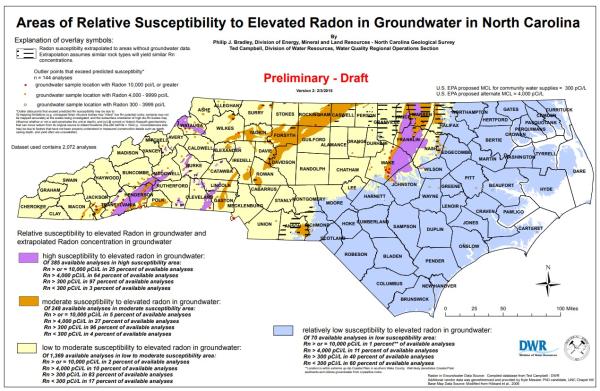
Radon in Groundwater
In 2015, the NCGS, along with the NC Division of Water Resources developed a draft map of the areas in North Carolina that might be susceptible to elevated levels of radon in groundwater. This map was first presented at the 2014 Southeastern Section of the Geological Society of America.
Arsenic is a naturally occurring element in rocks and soil that can dissolve into groundwater. When rock weathers, arsenic can be released into the environment from the breakdown of arsenic-bearing minerals such as sulfides, arsenopyrite, realgar, cobaltite, and tennantite. Naturally occurring arsenic is present in groundwater throughout North Carolina. The central part of North Carolina's Piedmont province is underlain by volcanic rocks and has the greater number of groundwater wells with detectable and elevated arsenic levels. The presence of arsenic in this area of the State is directly related to the underlying rock type.
Effects of Arsenic in Groundwater
Arsenic is colorless, tasteless, and odorless. The U.S. EPA has set a maximum contaminant level of 10 ug/L for groundwater. The non-enforceable goal is zero ug/L. Long-term exposure of arsenic in groundwater can lead to health effects such as skin, bladder, lung, liver, and kidney cancers and vascular diseases. Organic arsenic (a less toxic form) can also be found in fish and shellfish.
Arsenic in Groundwater - North Carolina
Naturally occurring arsenic in groundwater is present in North Carolina in concentrations ranging from 1 to 800 ug/L.
You can find more information on arsenic in groundwater in North Carolina through the following publications:
- The Geology of the Carolina Terrane in Chatham County, North Carolina
- North Carolina Groundwater Publications - search for arsenic in the search box
- Arsenic in North Carolina: Public Health Implications - published in the National Library of Medicine
The following text is from NCGS Information Circular 32: When the Ground Moves - A Citizen's Guide to Geologic Hazards in North Carolina.
When the Ground Moves - A Citizen's Guide
Storms
The North Carolina coastal zone includes barrier islands, sounds and estuaries. These areas are vulnerable to flooding and erosion by waves and high water driven by coastal storms. There are several types of shorelines including sandy beaches, swamp forests, bluffs and marshes. The narrow strand of sand known as the barrier islands is particularly vulnerable to these forces. Waves and currents continually shape this coastal landscape. No other part of North Carolina is more geologically active. Much of the change is slow and barely perceptible on a daily to yearly basis, but storms often cause very significant changes in a matter of hours. Proof of how quickly the barrier islands can change occurred on the morning of Sept. 18, 2003. Hurricane Isabel cut an inlet through Hatteras Island, severing NC Highway 12 and isolating Hatteras Village.
Inlet locations have changed throughout history. Currently, there are three inlets between Virginia and Portsmouth Island. Up to 16 inlet sites are known for this stretch of North Carolina’s coastline in historical times. It takes financial resources and large amounts of sand to keep inlets open, beaches nourished and roads passable as these geologic features constantly change.
Historic Sea Level Rise
The most significant long-term process causing change to our coastal zone is sea-level rise. At the peak of the last ice age about 18,000 years ago sea level was 425 feet lower than present and the North Carolina ocean shoreline was located 15 to 60 miles to the east. As the ice sheets melted, sea level began to rise. In general, the sea level has risen during this time but the rate of rise has varied and there have been periods of stability and falling sea level.
A significant amount of land that was once above sea level is now submerged. One line of evidence that sea level rise has affected humans comes from archaeological sites. Native American artifacts from on-land activities are being discovered under several feet of water. Also, maps from European settlers show entire islands that are now gone.
Beach Erosion
Recent and ongoing studies by the North Carolina Geological Survey, East Carolina University and the United States Geological Survey have demonstrated that the local geology is an important factor in how the barrier island system changes in response to natural processes and events. In many areas our beaches are disappearing. Each location has a unique set of causes for the beach erosion. Along the Outer Banks, mud-filled, ancient river and stream channels run under the barrier islands and are exposed along the ocean floor. The soft muddy sediments offer less resistance to the erosive force of waves and currents, especially during storm events. In some areas of the southern coastal zone, the underlying geologic units are not “sandy” enough to supply the sand needed to keep the barrier islands “healthy.” Areas such as these are more vulnerable to erosion than areas with more favorable geology.
Coastal Hazards - Additional Information
- What You Should Know About Erosion and Oceanfront Development
- Coastal Resiliency
- Coastal Management Oceanfront Shorelines
- Coastal Management Land Use Planning