
Guide: Determine if Your Stream is Subject to Riparian Buffer Rules
What is a riparian buffer?
To help protect water quality, North Carolina has riparian buffer rules protecting vegetated areas adjacent to intermittent and perennial streams, lakes, reservoirs, ponds, estuaries and modified natural streams. A riparian buffer is a strip of forested or vegetated land bordering a body of water. The vegetation and root systems in a riparian buffer help stabilize the stream-bank, preventing soil from eroding into the water. Riparian buffers also act as a filter to remove pollutants. Preserving riparian buffers is critical to protecting our water resources. Learn more online.
Guide: How to determine if your stream is subject to riparian buffer rules
If you live in a watershed with riparian buffer rules, and need to find out if the stream in your yard has protected buffers, you can follow the steps below to use the DEQ Division of Water Resources' online tools to answer some of your questions. The guide will walk you through searching for a stream or other waterbody using two different maps. The two maps are accessed by toggling the layer buttons on the right-hand side of the online mapping system linked below. If the stream or other feature is shown on either map, then it is subject to the buffer regulations.
Step One: Open the map, search
To determine if Riparian Buffer rules apply to your property/project, use the Riparian Buffer Map to determine if you are in a buffered basin.
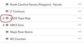
If you are located in a Buffered Basin, then use the NRCS Published Soil Survey / USGS Topo Mapping Tool map provided on the DWR website:
NRCS Published Soil Survey / USGS Topo Mapping Tool map
Search for your address using the search tool:

Step Two: Locate the stream
Locate the specific part of your property with the stream feature.
Step Three: Zoom out
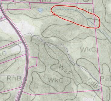
Zoom out so that the U.S. Geological Survey topographic map shows up. Determine if there is a stream at that location. Please note that streams in this map can show up as full lines, or as dashed or dotted lines.
Step Four: Adjust map layers
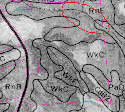
Turn off the topographic map layer to view the NRCS Published Soil Survey map.
Step Five: Check for a stream
Determine if there is a stream at that location on the soils map. Be sure you are looking at a stream line (shown using dots, circled in red in image below) and not a line showing a break in the soil type:
Step Six: If a stream (or other feature listed here) is shown on either map, then it is subject to the buffer regulations by default:
- Perennial streams
- Intermittent streams
- Modified natural streams
- Lakes and reservoirs
- Ponds (including beaver ponds)
Step Seven: Do you need a stream evaluation?
If a stream is shown on either map, but you believe that the maps have inaccurately depicted surface waters, the origin point of a stream or that the origin point of a stream is unclear, then you’ll need to request that your stream be evaluated. The evaluation will determine if your stream meets the requirements for riparian buffer regulation.
Step Eight: Find the right government agency for your stream determination
To get a stream determination, you should contact the proper local government authority that has the authority to make a determination about your particular stream.
To determine the buffer authority, use the Local Governments Administering Buffer Rules to determine if buffer regulations are implemented by a local government:
Delegated/Designated Local Governments Administering State Riparian Buffer Protection Rules
Step Nine: Submit a stream determination request
If your local government is on this list, contact them directly. If your local government is NOT on the list, then DWR is the buffer authority. To request a stream determination by DWR, submit a stream determination form to DWR to schedule a site visit with a staff member.
Step 10: Learn the rules
If buffers apply, please review the rules relevant to your area: riparian buffer rules.