
Bird Island Reserve
Visiting the site
Learn more about safety tips and the reserve rules and policies before your visit.
Camping and campfires are not permitted at this site.
Public access is primarily via the ocean beach from numerous public beach access points in Sunset Beach, while watercraft may land on the sandy shorelines within the Little River Inlet on the South Carolina side. With the closure of Mad Inlet in 1999 following Hurricane Bonnie, the public may walk the length of the island at all times.
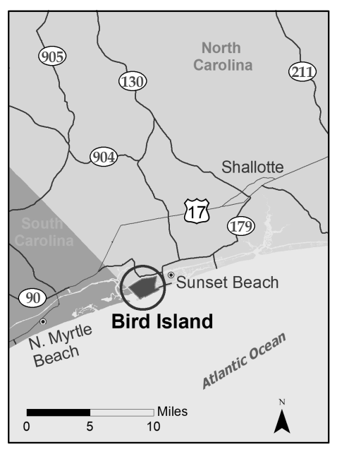
The Bird Island Reserve is located in Brunswick County, south of Shallotte. From Hwy. 17 South, turn left onto N.C. 904; then turn right onto N.C. 179. It will become Sunset Beach Boulevard. Cross the Intracoastal Waterway onto Sunset Beach. At the “T” intersection with Main Street, turn right.
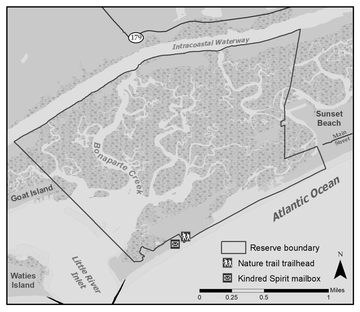
Parking is permitted on the side of the road and near the 40th Street crossover. Take the 40th street boardwalk beach access to the beach and turn right. Follow the beach until you reach signs indicating the boundary of the Reserve. The upland property begins at the boundary with Sunset Beach and continues about 1.2 miles until it meets the Corps of Engineers property approximately 0.4 miles from the state line.
The sound and marsh area of the Reserve may also be reached by boat from the Intracoastal Waterway using one of several creeks depending on vessel draft and tide levels (e.g. Bonaparte Creek, Clayton Creek, East River).
There are limited paid parking spaces at the 40th and Main Street intersection. Additional paid parking lots and spaces can be found along N Shore Drive and at the pier.
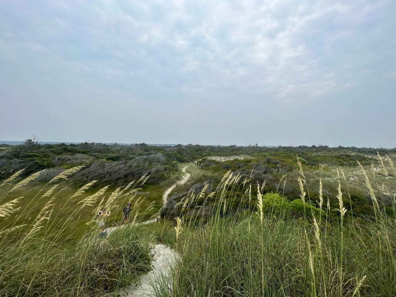
Cross the 40th Street beach access and walk west, down the beach strand. A nature trail is located 1.5 miles from the beach access.
Guided Nature Walks
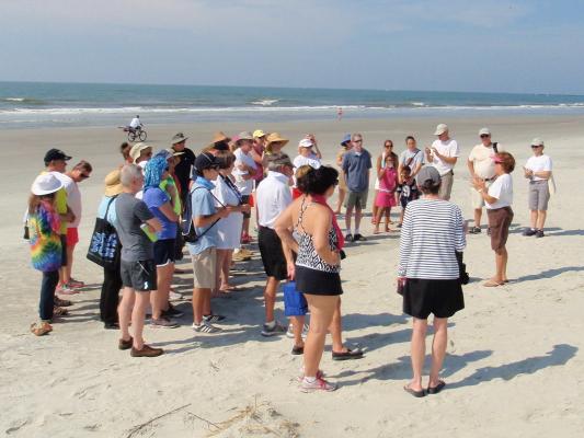
Educational walks to Bird Island Reserve in Sunset Beach are hosted by Bird Island Steward volunteers with the North Carolina Coastal Reserve and National Estuarine Research Reserve. Walks occur every Wednesday during the summer of 2026 from May 27 to September 9. Meet at the marsh lookout at 40th Street and Main Street at 8:30 AM. The walk takes about 1.5–2 hours and covers 1.4 miles to the Kindred Spirit mailbox (2.8 miles round trip). Participants should bring water and wear closed-toe shoes and pants.
Natural Features
The Bird Island Reserve has pristine sandy white beaches, high natural dunes, and over 1,000 acres of beautiful salt marsh and tidal creeks.
Bird Island is an undeveloped barrier island located at the southwestern edge of the North Carolina coast, situated between the Town of Sunset Beach and the Little River Inlet in South Carolina. The Reserve site encompasses 1,481 acres consisting of approximately 135 upland acres and more than 1,300 acres of marsh, intertidal flats, and subtidal area. This site is also a Dedicated Nature Preserve, authorized by G.S. 143B-135.250.
The Reserve site represents excellent examples of barrier communities with several occurrences of rare species. The following barrier island biotic communities are present: upper beach, dune grass, maritime dry grassland, maritime wet grassland, maritime shrub thicket, maritime shrub swamp, brackish marsh, salt shrub, salt flat, and salt marsh. The most notable species of the island are nesting loggerhead sea turtles (Caretta caretta) and seabeach amaranth (Amaranthus pumilus), a plant of the foredune area. Both species are listed as threatened by the federal and state governments.
Upper beach
The area between the surf zone and the dunes is subject to harsh conditions like shifting sands, glaring sun, strong winds, salt spray, and storm surge. Only a limited number of species are specifically adapted to survive here. Flowering plants include sea rocket, orach, dune spurge, and seaside elder. Grasses such as sea oats and beach panic grass grow here. The upper beach is a critical nesting area for loggerhead sea turtles. Some ground nesting birds such as the American oystercatcher, terns, black skimmer, and Wilson’s plover build nests directly on the sand. The ghost crab makes deep tunnels under the sand to avoid predators and high temperatures.
Sand dunes
Plants are found in greater numbers as distance and elevation above sea level increase.The dune system at Bird Island has prominent frontal and secondary dunes, some in excess of 20 feet high. Sea oats are the dominant vegetation. Their extensive underground stem and root networks stabilize the dunes by literally holding the sand together. Other dune plants such as croton, pennywort, and evening primrose are adapted to the windy conditions. They have flexible leaves and stems and grow close to the sand.
Maritime grasslands
The depression behind the sand dunes is better protected from salty wind and waves. Here, grass and herb species include saltmeadow cordgrass, broomsedge, carex, prickly pear cactus, peppergrass, blanket flower, goldenrod, marsh fimbry, pennywort, and beach morning glory.
The grasslands vary from seasonally or permanently wet in lower areas to well-drained in areas of higher elevation.
Maritime shrub thicket
Farther from the effects of the ocean, where salt spray and temperature variations are reduced, a mix of vine, shrub and tree species grows into a shrub thicket. White-tailed deer, non-native red fox, bobcat, opossum, raccoon, marsh rabbit, and cotton mouse use the shrub thicket for protection and shelter.
Salt marsh
Lunar tides flood the intertidal salt marshes twice each day. Supratidal marshes remain above water except during occasional spring tides and storm tides. Saltmarsh cordgrass, which dominates the intertidal marsh, is adapted to dramatic changes in salinity and temperature. This abundant, tall plant regulates salt concentrations in its cells by releasing excesses through pores on its blades.
Tidal mud flats
Expansive and seemingly barren flats are easy to see at low tide. Decaying marsh grass, or detritus, is deposited with each tide. These nutrients support a food web of crabs, fish, snails, and mussels. Wading birds and shorebirds come to the exposed mud flats to feed during low tide. The sediments sometimes have a “rotten egg” smell due to the hydrogen sulfide gas produced as decomposers break down organic matter in the marsh.
Sea beach amaranth
Found in the foredune, this rare plant does not tolerate disturbance such as development, beach nourishment, and erosion. Only 55 populations are known to exist. As a result, the plant was listed as federally threatened in 1993.
Diamondback terrapin
The diamondback terrapin is a state species of special concern. It is the only reptile specifically adapted to survive in fresh or salt waters. It prefers the brackish water of the salt marsh. The shell of this reclusive turtle has distinctive diamond-shaped scales.
Loggerhead sea turtle
Female turtles crawl out of the sea to nest during the summer. Hatchlings mature in the sea and the females may return many years later to nest in the same region. It is estimated that only one in 1,000 of these threatened sea turtles will survive to adulthood.
Mammalian predators
Predator populations fluctuate from year to year. Clever predators, such as red fox and coyotes, use a variety of food sources and adapt readily to living in close association with human development. The result can be noticeable impacts to threatened and rare wildlife, including predation to sea turtle and shorebird nests.
Birds
The barrier island bird community includes brown pelican, Wilson’s plover, black skimmer, ibis, gulls, herons, and egrets. Piping plover, willet, eastern painted bunting, wood stork, and several types of tern are present, but less common.
Frequently Asked Questions
- Fires, fireworks, target shooting, nudity, and camping are prohibited.
- Hunting is allowed as per state and local hunting rules.
- Producing noise that is disruptive to wildlife or other visitors is prohibited.
- Removal or disturbance of plants, animals, fungi, or cultural resources is prohibited.
- Littering is prohibited. Leaving any personal property unattended within the boundaries longer than 24 hours is prohibited.
- Recreational/off-road motorized vehicles are prohibited. Bicycles are allowed on the ocean beach.
- Written authorization is required for organized events, commercial activities, and other special activities.
Yes, the reserve is open to visitors year round. Visit at your own risk. Sites are remote and conditions can include natural hazards such as
insects and poisonous plants.
Yes, from the beach access at 40th street, it is about a 1.4 mile walk to the mailbox, making it a 2.8-mile round trip.
Yes, however off-leash pets are prohibited.
There are no public restrooms or facilities available at Bird Island Reserve. Public restrooms can be found near the gazebo at the Sunset Beach pier.
Bird Island was privately owned from 1771 through 2001. Since that time, the state of North Carolina purchased the Bird Island Reserve property with funds from N.C. Land and Water Fund, N.C. Natural Heritage Trust Fund, N.C. Department of Transportation, and the General Assembly, completing acquisition in 2021. Many years of local citizens’ effort, particularly the Bird Island Preservation Society, contributed to the inclusion of Bird Island in the Coastal Reserve program.
Bird Island is managed by the N.C. Division of Coastal Management to protect the island’s ecosystems and organisms for research, education and compatible uses. Support and assistance of the Bird Island Preservation Society and its volunteer stewards is gratefully acknowledged. This site is also a Dedicated State Nature Preserve. The North Carolina Coastal Reserve & National Estuarine Research Reserve is a part of the N.C. Division of Coastal Management, a division of the N.C. Department of Environmental Quality.
This natural area is one of 10 sites that make up the North Carolina Coastal Reserve & National Estuarine Research Reserve. Preservation of Bird Island Reserve allows this coastal ecosystem to be available as an outdoor laboratory where scientists, students and the public can learn about processes, functions and influences that shape and sustain the coastal area. Traditional uses, including recreation, are allowed as long as they do not disturb the environment or organisms or interfere with research and educational activities.
Printable Brochures
Site map
Site Management
Visit the Kindred Spirit Mailbox
Please note that the flag mentioned in the video is no longer there.