
Hazard Forecasting
Know what to expect and stay aware of forecasted water levels near streams, rivers, sounds, and the coast.
Hazard forecasting tools help communities anticipate flooding, storm surge, extreme rainfall, and other coastal hazards before and during events. By combining real-time observations with predictive models, these tools support emergency response, public communication, and day-to-day decision-making.
In coastal North Carolina, forecasting is especially important due to the interaction of ocean conditions, river systems, and changing climate patterns. These resources can also inform longer-term planning decisions, including infrastructure design, land use, and hazard mitigation strategies.
For a broader view of hazard risk across the United States, explore the U.S. Natural Hazards and Climate Change Map from Columbia Climate School. This interactive tool allows users to visualize multiple hazards—such as flooding, extreme heat, wildfire risk, and sea level rise—alongside population and infrastructure exposure.
Getting Started
Before exploring the available options below, begin your search with the U.S. Natural Hazards and Climate Change Map by clicking the link or the image below.
Hazards
Sea Level Rise Reports and FAQs
- Access the North Carolina 2015 Sea Level Rise Assessment Report from the Coastal Resources Commission Science Panel
Describes 30-year sea level rise projections and establishes the framework for coastal planning in North Carolina. - View the 2024 North Carolina Science Panel Sea Level Rise Update
Provides the most recent updates to sea level rise projections based on current science and modeling. - Learn how sea level changes using NOAA’s Sea Level Rise explainer
Explains the causes of sea level rise, including thermal expansion, land subsidence, and ice melt.
Interactive Mapping
- Explore local flooding scenarios using the NOAA Sea Level Rise Viewer
Visualize inundation depth, marsh migration, social vulnerability, and high tide flooding. - Assess coastal flood risk using The Nature Conservancy Coastal Resilience Mapping Portal
Identify potential inundation from storm surge, coastal storms, and future sea level rise conditions.
Generate Local Sea Level Rise Summaries
- Visualize future sea level projections using the NASA Sea Level Projection Tool (IPCC AR6)
Explore and download projection data and generate summaries of future sea level rise and nuisance flooding scenarios.
Local Data & Trends
- Access long-term tide gauge data using the NOAA Sea Level Trends Tool
Evaluate local sea level rise trends for specific locations across North Carolina and the U.S.
Historical Trends
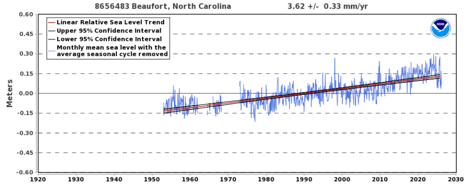
According to the local NOAA Tide Station, the relative sea level trend at Beaufort, North Carolina, is approximately 3.62 millimeters per year (± 0.33 mm/year, 95% confidence interval), based on monthly mean sea level data from 1953 to 2025. This is equivalent to a change of approximately 1.19 feet over 100 years.
Current Tides and Sound/River Flooding
Sea level rise and more extreme rainfall events are contributing to higher high tides and, in some cases, record stream and river levels. Monitor real-time conditions and forecasts to stay aware of potential flooding in your area.
Monitoring Tools
- Monitor flood conditions using the NC Flood Inundation Mapping and Alert Network (FIMAN)
View weather radar and stream, sound, and river gauge data to determine if flooding is expected in your community. Includes flood scenarios showing potential building damage and community impacts. - View tide forecasts and water level predictions using NOAA Tides and Currents (NC Tides)
Access detailed tidal forecasts and observed water levels for locations across North Carolina. - Access river stage forecasts from the NOAA Southeast River Forecast Center (SERFC)
Monitor river levels and flood predictions across North Carolina to anticipate riverine flooding. - Monitor real-time and historical water levels using the NOAA Coastal Inundation Dashboard
Provides observed, forecasted, and historical water level data from NOAA water level stations across the U.S.
Engage the Community with Citizen Science
- Explore and contribute to coastal flooding observations through the NC King Tides Project
View photos and records of king tide events and learn how to document flooding in your community. - Map and report nuisance flooding using the NC Sunny Day Flooding Project
A continuation of the King Tides Project focused on documenting sunny-day flooding events across coastal North Carolina.
Hurricane and Storm Surge
North Carolina’s coastline is highly vulnerable to hurricanes and associated hazards, including storm surge, heavy rainfall, and coastal flooding. Storm surge is often the greatest threat to life and property during a hurricane, as strong winds push ocean water inland and combine with normal tides to produce dangerous flooding.
Monitoring forecasts and understanding potential impacts can help communities prepare for and respond to storm events.
Forecasting & Tracking Tools
- Track hurricanes and view official forecasts from the NOAA National Hurricane Center (NHC)
Monitor active storms, forecast tracks, intensity, and warnings. - View tropical weather forecasts and hazard outlooks from the National Weather Service (NWS)
Access rainfall outlooks, storm surge watches and warnings, and hazard graphics.
Storm Surge & Flood Risk Tools
- View storm surge inundation scenarios using NOAA’s National Storm Surge Hazard Maps (SLOSH model)
Explore potential storm surge flooding for evacuation planning and risk assessment. - Monitor real-time coastal flooding using the NOAA Coastal Inundation Dashboard
View current and historical water levels and flooding impacts across coastal communities. - Assess flood risk using the NOAA Coastal Flood Exposure Mapper
Visualize people, infrastructure, and natural resources exposed to coastal flooding, storm surge, and sea level rise.
Preparedness & Hazard Information
- Access hurricane preparedness and evacuation guidance from ReadyNC
Learn about hurricane hazards, preparedness actions, and evacuation planning specific to North Carolina.
Marine Weather
Marine weather conditions, including wind, waves, and offshore storms, can significantly influence coastal flooding, navigation safety, and shoreline impacts. Monitoring real-time conditions and forecasts can help communities and coastal users prepare for changing marine conditions.
Marine Observations & Real-Time Conditions
- Access real-time ocean buoy observations from the NOAA National Data Buoy Center (NDBC)
Includes wave height, wind speed, water temperature, and atmospheric conditions. - View site-specific conditions at the Diamond Shoals Buoy (Cape Hatteras)
Provides localized wind, wave, and water condition data.
Marine Forecasting Tools
- View coastal and offshore marine forecasts by zone from the National Weather Service (NWS)
Includes wind, wave height, and marine hazard information. - Access Eastern North Carolina marine forecasts from the NWS Newport/Morehead City office
Covers coastal waters, sounds, and offshore zones. - Explore NOAA’s marine zone interactive forecast map
Select specific zones to view detailed marine forecasts.
Additional Marine Forecast Resources
- Access NOAA marine point forecasts for location-specific conditions
Provides detailed forecasts for wind speed, wave height, and marine conditions. - View wind and swell forecasts using the BuoyWeather North Carolina marine map
Interactive visualization of marine conditions across coastal waters.
Drought and wildfire conditions can affect water supplies, ecosystems, agriculture, infrastructure, and public safety across North Carolina. Extended dry periods may increase wildfire risk, particularly when drought follows periods of above-average rainfall that promote vegetation growth.
Additional drought monitoring and outlook resources are available through the U.S. Drought Monitor North Carolina page and the National Integrated Drought Information System (NIDIS).
Drought Resources
- Monitor statewide drought conditions through the U.S. Drought Monitor North Carolina page
Provides current drought classifications, maps, and drought condition summaries for North Carolina. - View drought advisories and response information from the NC Drought Management Advisory Council
Includes current drought classifications, advisories, and recommended response actions. - Explore regional drought conditions through the Southeast Drought Early Warning System
Provides drought outlooks, forecasts, climate indicators, and regional monitoring information across the southeastern United States.
Wildfire Resources
- Access wildfire prevention and fire safety resources through the NC Forest Service
Provides wildfire prevention guidance, outdoor fire safety information, and wildfire awareness resources.